Contributor: Ashley Nail Murphy. Lesson ID: 14203
Have you ever been on a road trip? A road trip is fun, but it takes a lot of planning! One way to get ready for a trip is to learn about maps! Learn how to locate all the different parts of the U.S.

At the end of 2024, the earth was home to 8.2 billion people.
Whoa! That’s a lot of people on one planet!
All those people are spread out across the earth. They live in different countries, but they all call this planet home.
People love to travel and learn more about other places. You may travel across oceans, mountains, and deserts to visit new cities, countries, or regions.

The United States of America!
You may think you know a lot about the United States, but it is a big country!
Learn more about the United States as you take a road trip zig-zagging across the country.
Where Is the United States of America?
Look again at a globe.
Now, imagine the surface of a globe being cut apart and laid out flat. This is how a world map is made!
Look closer at how a world map is organized.
First, a globe and a world map are both organized by hemispheres. A hemisphere is half of a spherical body, like the earth, which can be split in half in two different ways.
The United States of America is in the Northern hemisphere and the Western hemisphere!
Next, the earth is split into continents.
A continent is a large, continuous land mass typically distinguished by geographical, cultural, and political boundaries. The earth has seven continents.

The United States is part of North America!
Now, zoom in on the North American continent.
Click on the purple icons below to learn which countries and oceans border the United States. This can help you find the United States on a map!
States and Capitals
Now that you can locate the United States, you can plan your road trip!
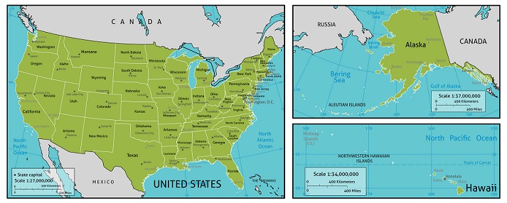
The U.S. has 50 states you can visit. 48 of those states border each other and are part of what is called the contiguous states.
Hawaii and Alaska do not share borders with other states and are not geographically connected to the mainland of the U.S. Hawaii is a group of islands in the Pacific Ocean. Alaska is a state in the far north of North America and borders Canada.

This means you can easily drive to all 48 states since they are connected! However, you may have to visit Hawaii and Alaska by airplane!
Each of the 50 states has its own unique identity. For example, Florida is known as the Sunshine State and is famous for its beaches and tropical climate.
Nebraska is called the Cornhusker State because of its strong agricultural heritage and identity as one of the leading corn-producing states in the U.S.
Besides cultural differences, each state has its own government and capital city. These capitals are important places where state governments make decisions, like what laws their citizens need to be safe and prosperous.
Look at the map of U.S. states and capital cities.

Regions
Now that you know the locations of the 50 states, you can decide where to start your road trip!
U.S. states are commonly grouped into regions based on geography, culture, and economics. These regions are a group of states that are close together and described by their locations on the United States map.
Look at the five regions below.

Find the Southwest Region. This region is known for its desert landscape, Native American heritage, Spanish and Mexican influence, oil and energy production, and tourism to National Parks.
Each region has its own distinct climate, culture, and industry, making its part of the country special.
If you are almost ready for your road trip, head to the Got It? section to practice navigating maps of the United States!